Introduction
The objective of this lab was to create a model terrain surface and survey the area without using high tech equipment. In order to accomplish this, a coordinate system would have to be developed, as well as a system for measuring the elevation of the surface. No specific instructions were given, although a tape measure, meter stick, and string were given so critical thinking was a must. This lab also represents the collection of data in the field, with the analysis on computer software to come later.
Methodology
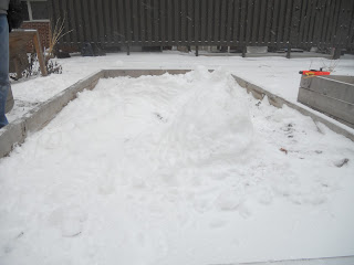
This lab utilized a rectangular planter box located in the Phillips courtyard. A terrain made out of snow was created in the box, consisting of plains, mounds, ridges, and valleys.
The next step was to design a coordinate system that would be used to survey the terrain. The shorter sides were deemed the X-axis, while the long sides were designated as the Y-axis. Ten centimeter increments were chosen, and strings were stretched across the long way of the planter box. To make accurate height measurements, a string spanning the short way of the box was strung on top of two boards. Then, the boards were slid down the box to marked 10 cm increments.
The measurements were made by placing a meter stick at the top of the terrain surface at each intersection and measuring to the top of the string spanning the X-axis.
The measurements were then recorded and added to an Excel spreadsheet. Because the surface was measured from the top of the terrain to the strings above, these measurements were actually the inverse of the elevation of the terrain. To correct this, each inverse measurement was subtracted from 25 (25 cm for the distance from "sea level" to top of the boards used to measure).
Discussion
The raw data shows the terrain elevation at each 10 cm interval that was measured in the planter box. It will be interesting to upload the data to ArcGIS and see the three dimensional model and compare it to the pictures of the terrain that was created in the snow. After completing this lab, I am concerned that the 10x10 cm measurements we took might be too coarse to accurately represent the data. A more precise measurement increment, such as 5x5 cm, might have been the better option.
Conclusion
I found this to be a very stimulating and interesting lab to complete. There were no specific instructions given, so our group had to come up with the process used to survey the terrain surface. It really stressed the importance of collaboration to accomplish our goal. One concern I have over this lab is that the 10-x10 cm measurements that we used might be too coarse. It was also very interesting to see the different ways that people think and ideas that they contribute. Finally, as most people that use technology often know, there is always the chance that technology can fail at any time. This exercise was useful to display the importance of understanding concepts and the ability to think critically and on your feel to solve problems.


No comments:
Post a Comment